In the world of motorcycling, the Iron Butt Association has some notoriety. You can become a member by riding 1,000 miles in 24 hours. But the best-known event is the Iron Butt Rally, in which participants ride at least 11,000 miles in 11 days ("safely," the web site says) while reaching specific checkpoints. Stories of brain-scrambled riders doing weird stuff abound.
Which brings me to my point. I love motorcycling. I look at those Iron Butt guys and think, "Yeah, let's take something we love, and do it until we hate it."
I liked my trip. I didn't overdo. In that last week, after I went farther east than I originally intended and had to zoom back across the country for Mother's Day, I was riding a little more grimly than I did at first, just hoping to dodge the weather and get some miles in each day. Even so, I enjoyed watching the country flow by me.
So, first impression: this is a big country. There is a lot of room out there; it's not all built up. There's a lot going on. Every region has its own unique features, but the constant presence of national chain stores and restaurants in larger towns and cities was either reassuring or, depending on your point of view, depressing. I would say the pivotal states on the trip were Texas and Oklahoma, where you can be in pure desert on one end of the state and in wet, green country on the other end.
The roadsides were cleaner than I remember from earlier decades. My excursion to Puerto Palomas in Mexico, opposite Columbus, New Mexico, reminded me of how frightfully bad public trash can be in Mexico. In contrast, it was hard to find litter on the sides of U.S. highways. This might be a testimony to the success of all those "Adopt a Highway" litter collection efforts. More power to 'em.
A lot of people stay where they were planted. I guess I could plead guilty to that, too – I've moved around Southern California some but not beyond that. People get comfortable with their little circles, with the rules and conditions that govern where they live. Should they move? Maybe everyone should, just to gain some understanding of the things they had been taking for granted.
Where would I go? In my travels I found that I was drawn to water. The abundance of streams and lakes, especially east of the Mississippi, just fascinated me. And yet, as I rode back through New Mexico and the mesas of the Navajo and the Zuni, I felt a kinship with that land too – and there isn't much water there; that's for sure. There's no one place that fulfills all my needs.
Would I take another long trip like this one on a motorcycle? It's probably too soon to answer that. During the trip I came up with a long list of reasons why the trip would make more sense in a car. But I do love riding. I suspect that I'll do shorter trips on the bike in the future and try to loop my girlfriend into another long trip by car. I didn't camp on this trip; I could barely carry my small amount of gear as it was, much less camping gear. But a car would make it practical to bring camping gear.
I'm a few years from retirement yet. I took this trip partly because I didn't know how long my health would allow me to do stuff like that. For a long time, I hope. When I retire I will take a serious look at doing some more unstructured roaming, free to spend a lot of time in spots that I take a liking to. That will make me feel like a rich man, in spirit.
Thursday, May 14, 2015
Saturday, May 9, 2015
Home
One month to the day, with 6,885 miles on the little Ninja, I'm here. I walk around this house and everything looks a little different, displaced, as if I were in just another stop along the ride.

I arrived yesterday afternoon and spent time talking to some loved ones and zoning out rather than working on a blog post. I'm starting this after a long night's sleep.
The day started cold and rainy in Prescott, Arizona. (Despite my hopes, I did not escape the weather.) Highway 89 south from Prescott winds and climbs out of town, then descends to open plains. It reaches about 6100 feet going over the mountains, and it is a fiendish little road, with many, many tight turns in the first 15 miles signposted for 20 MPH. And, in the wind and rain and with my new low-performance tires, I took those turns at 20. I was a slow, super-conservative rider. Miraculously, no one overtook me during that entire time. Once I got down to the plains, to occasional sun and dry pavement, I picked up the pace. It's really a lovely trip through the cedar-dotted plains and ranchlands. The ranches of Peeples Valley are particularly pretty. I rode through low, rolling hills to the folksy town of Yarnell. That's where an entire team of 19 "hot shot" firefighters from Prescott died when a fire unpredictably turned on them on June 30, 2013.
South of Yarnell, the earth just fell away. The speed limit dropped to 30 MPH and the road seemed to plunge off the level ground of Yarnell into the vast, open view to the south. It was more like being in an airplane than on a highway. That stretch is one of the most dramatic roads I've traveled. The road clings to the steep mountainside and descends almost 2000 feet in several miles to the town of Congress, below.
Once on the flats at Congress, the road stayed flat and straight for many miles, passing ranges of hills but holding to long, long straight stretches through desert and farmland. The wind blew strongly from straight ahead. I twisted the throttle and accepted the lower MPG in my haste to get home.
My eastward route on this trip was entirely separate from my westward route, except for 6 miles of US 60 between Salome and Hope, AZ. As I passed that way I looked for the gorgeous bloom of ocotillos that I had seen on April 9, but it was long gone.
Around Hope I began passing numerous RV parks. I like the desert, but I wouldn't want to be a snowbird parked in some RV ghetto in the middle of nowhere all winter, nowhere near any form of culture or entertainment. However, some people must like it. There were sure a lot of spaces out there, although now, in early May, they were beginning to clear out. A sign on a Mexican restaurant said "Closed - Reopening September 1."
The front that dumped rain (and later snow, I learned!) on Prescott still held isolated showers, sometimes in lacy veils that didn't quite reach the desert floor, sometimes in cloudbursts that did. None of them impacted me, although as I crossed the Colorado River bridge into California on Interstate 10, I did get a minute or two of rain.
I was dressed in more clothes that I had worn on the entire trip, spurred by the rain and cold at my starting point. But I remained dressed that way during the entire ride. It never really warmed up much. Across the California desert the wind gusted strong from the side and ahead. I rode along tilted to the left and wiggling in the gusts, passing slower trucks. In the Coachella Valley the wind eased a little. Snow was falling all around San Jacinto peak and rain was falling into the "Indian Canyons" south of the peak. The summit was buried in clouds, as was Mount San Gorgonio, which was undoubtedly getting a snowfall, too. I barely saw any snow during my entire trip (tiny glimpses in New Mexico) and now, back in my local neighborhood, I was getting the full show.
As Interstate 10 passed between those two mighty peaks, at the town of Banning, an ugly rainstorm began. The crowded freeway, dim light, and heavy rain made for some paranoid riding. I pushed through and 10 miles later the rain stopped and the road gradually dried. Other pockets of showers were visible all around the route ahead, but they didn't cross my path.
To complete my trip, I did a little lane-splitting in slow traffic past Ontario airport. California is the only state in which that's legal. Yeah, the little Ninja was wide-hipped, as shown in the photo at the top of this post, but it still fit those lane holes. Then I used carpool lanes for about 25 miles until the last run up the Glendale Freeway to home.
I was glad to see my son, Casey, who was at the house. We talked for a while and then he left for an appointment. Later my girlfriend Deni came over and I talked about how much I had missed her. I gave her a trinket that I had bought on the Zuni reservation. We'll be getting together again this weekend, when I have recovered a bit from my travels.
At some point I zonked out on the couch, then woke at midnight and went upstairs to bed. Now there are pieces of mail to handle, plenty of cleaning up to do, and plenty of catching up on work emails.
What did I expect on this trip? What did I discover? I will post about that, but not this morning. That will take some time to put into words.
Friday, May 8, 2015
Crossed Fingers
Today is my last run. I'm headed for home. It's 47 degrees in Prescott, headed for a high of 50 with a chance of thunderstorms. Same for the other roads before I reach Interstate 10 near the Colorado River with a high of only 73 in Blythe, a notoriously hot place. And, big surprise, strong winds from the west are forecast. This trip isn't letting me go easily.
The first part of the run, Highway 87 south, is a bunch of twisties over a mountain range. I better get out of here before it starts raining.
The first part of the run, Highway 87 south, is a bunch of twisties over a mountain range. I better get out of here before it starts raining.
Wind from the West
(I started this on Thursday night but fell asleep before I posted. Finishing it now, Friday morning.)
Yesterday's ride from Oklahoma City was all about crosswinds and headwinds. I'm not complaining, though. I got on the road at 8:30 in the morning and later in the day the city was pummeled by several tornadoes and up to 5 inches of rain. So I'm very glad that I left.
Still, fighting those winds on a 250cc motorcycle can be exhausting, physically and psychologically. And late in the day today, Thursday, the wind was back. But I'm getting ahead of myself.
When I left Albuquerque this morning the winds were still. Interstate 40 climbed for miles away from the Rio Grande Valley. I was headed for Grants, where I would turn off on a long side road to the Zuni reservation. Before Grants, the highway passed through several other reservations – Acoma, Laguna, and others. Various styles of pottery and jewelry originate from these tribes. I have an Acoma bowl, jet-black, with a stylized fox or coyote etched around the sides. It's always been a favorite. And casinos! Almost every tribe has a casino, and more are seemingly randomly placed along 40. I passed at least a dozen of them on my ride today.
Although I was wearing some warmer clothing, it wasn't enough. It was a little cold this morning. Not that it would bother you too much just walking around, but going into that coolness at 70 MPH for hours will really chill you. At Grants I put on some more clothes and took off down Highway 53.
The red rock and juniper country just does something to me. As much as I loved the abundant water in the South, this kind of country makes my soul breathe easy. On I went for miles, climbing steadily higher. I passed the side road to the Bandera volcanic crater and the nearby ice cave, but kept going. I crested the Continental Divide at over 7800 feet. Soon after, a Mountain Bluebird took off from the side of the road. Some distance on the other side of the divide was El Morro National Monument. I took some time here to walk the interpretive trail. A pool at the base of the sandstone cliffs is the only surface water for 40 miles or more, and for a thousand years native Americans, Spaniards, and frontier travelers have carved their names or petroglyphs into the stone.


White-throated Swifts wheeled through the sky above the stone. They love cliffs as roosting and nesting places. This vertical crack at one end of the cliff was perfect for them.

Off I went, through the Ramah Navajo reservation and on to Zuni. There were many beautiful mesas along the way. This one was typical, except for the white sentinel stone standing by itself, on the plains away from the cliffs. It reminded me of an orchestra conductor.

At the town of Zuni I secured my Mother's Day gift. I traveled westward and crossed the Arizona border. The mesas fell behind and the land was sage and cedars at first, then just endless sage scrub on gently undulating land, seemingly forever. The west wind was blowing hard now and the little Ninja had to work hard to keep up speed. I turned north to Sanders to rejoin I-40.
The wind was howling, so for 50 miles I "drafted" a big rig, following closely enough to gain some relief from the wind blast while maintaining a distance where I could brake safely. We passed turnoffs for the Petrified Forest and the Painted Desert. I have been to those places as a small child, but there was no time to visit them today. At Holbrook I drafted another, slower big rig into the town of Winslow. My eventual destination was Prescott and I was going to go there over the White Mountains.
Highway 87 ran straight into the headwinds. It was tough keeping any speed. It crossed the Little Colorado River (just a trickle today) and led out of town across open grazing land, past a state prison and then on toward low hills. There was little traffic. Cedars and sage were the dominant plants, with the omnipresent cheatgrass. Jacks Canyon, a gorge with almost vertical walls and verdant greenery, cut through the dry plains, its top level with the surroundings so that you could only see it when you were right next to it. The road rose gradually and then steeply into the White Mountains and ran for many miles through pine forests. It reached 7400 feet. It was cold! I took a turn on 260 west and soon the road descended out of the pines into oaks and then into desert plant communities. The views were vast and a 6% grade ran downhill for 9 miles. At the bottom was Camp Verde and the Verde River.
Here I had to get on Interstate 17 for a run of several miles before taking an exit to Prescott. That highway was nuts, with many aggressive drivers jockeying to pass slow trucks on a long uphill with headwinds. I dropped from sixth gear to fifth, and even to fourth at one point, looking for more power to keep from being mowed down.
The road from the interstate to Prescott was 30 miles long. It ran through a stretch of chaparral that looked just like something from Southern California, and then got into Prescott Valley, which was also reminiscent of the generic, national-chain landscape of SoCal. I checked into a hotel at the eastern edge of Prescott itself and called my friend Linda. We headed to the historic district and had drinks at the Palace Saloon, the most venerable institution on Whiskey Row, across the street from the town square.

Then it was a nice lasagna dinner, and I was dropped at the hotel to begin blogging. At some point, sleep overcame me before I published my post.
Yesterday's ride from Oklahoma City was all about crosswinds and headwinds. I'm not complaining, though. I got on the road at 8:30 in the morning and later in the day the city was pummeled by several tornadoes and up to 5 inches of rain. So I'm very glad that I left.
Still, fighting those winds on a 250cc motorcycle can be exhausting, physically and psychologically. And late in the day today, Thursday, the wind was back. But I'm getting ahead of myself.
When I left Albuquerque this morning the winds were still. Interstate 40 climbed for miles away from the Rio Grande Valley. I was headed for Grants, where I would turn off on a long side road to the Zuni reservation. Before Grants, the highway passed through several other reservations – Acoma, Laguna, and others. Various styles of pottery and jewelry originate from these tribes. I have an Acoma bowl, jet-black, with a stylized fox or coyote etched around the sides. It's always been a favorite. And casinos! Almost every tribe has a casino, and more are seemingly randomly placed along 40. I passed at least a dozen of them on my ride today.
Although I was wearing some warmer clothing, it wasn't enough. It was a little cold this morning. Not that it would bother you too much just walking around, but going into that coolness at 70 MPH for hours will really chill you. At Grants I put on some more clothes and took off down Highway 53.
The red rock and juniper country just does something to me. As much as I loved the abundant water in the South, this kind of country makes my soul breathe easy. On I went for miles, climbing steadily higher. I passed the side road to the Bandera volcanic crater and the nearby ice cave, but kept going. I crested the Continental Divide at over 7800 feet. Soon after, a Mountain Bluebird took off from the side of the road. Some distance on the other side of the divide was El Morro National Monument. I took some time here to walk the interpretive trail. A pool at the base of the sandstone cliffs is the only surface water for 40 miles or more, and for a thousand years native Americans, Spaniards, and frontier travelers have carved their names or petroglyphs into the stone.


White-throated Swifts wheeled through the sky above the stone. They love cliffs as roosting and nesting places. This vertical crack at one end of the cliff was perfect for them.

Off I went, through the Ramah Navajo reservation and on to Zuni. There were many beautiful mesas along the way. This one was typical, except for the white sentinel stone standing by itself, on the plains away from the cliffs. It reminded me of an orchestra conductor.

The wind was howling, so for 50 miles I "drafted" a big rig, following closely enough to gain some relief from the wind blast while maintaining a distance where I could brake safely. We passed turnoffs for the Petrified Forest and the Painted Desert. I have been to those places as a small child, but there was no time to visit them today. At Holbrook I drafted another, slower big rig into the town of Winslow. My eventual destination was Prescott and I was going to go there over the White Mountains.
Highway 87 ran straight into the headwinds. It was tough keeping any speed. It crossed the Little Colorado River (just a trickle today) and led out of town across open grazing land, past a state prison and then on toward low hills. There was little traffic. Cedars and sage were the dominant plants, with the omnipresent cheatgrass. Jacks Canyon, a gorge with almost vertical walls and verdant greenery, cut through the dry plains, its top level with the surroundings so that you could only see it when you were right next to it. The road rose gradually and then steeply into the White Mountains and ran for many miles through pine forests. It reached 7400 feet. It was cold! I took a turn on 260 west and soon the road descended out of the pines into oaks and then into desert plant communities. The views were vast and a 6% grade ran downhill for 9 miles. At the bottom was Camp Verde and the Verde River.
Here I had to get on Interstate 17 for a run of several miles before taking an exit to Prescott. That highway was nuts, with many aggressive drivers jockeying to pass slow trucks on a long uphill with headwinds. I dropped from sixth gear to fifth, and even to fourth at one point, looking for more power to keep from being mowed down.
The road from the interstate to Prescott was 30 miles long. It ran through a stretch of chaparral that looked just like something from Southern California, and then got into Prescott Valley, which was also reminiscent of the generic, national-chain landscape of SoCal. I checked into a hotel at the eastern edge of Prescott itself and called my friend Linda. We headed to the historic district and had drinks at the Palace Saloon, the most venerable institution on Whiskey Row, across the street from the town square.

Then it was a nice lasagna dinner, and I was dropped at the hotel to begin blogging. At some point, sleep overcame me before I published my post.
Wednesday, May 6, 2015
Sopaipillas
Sopaipillas are one of my favorite things about Albuquerque.

Here we see them pictured with a big plate of carne adovada, another New Mexican specialty. I had to hurry across the street to this restaurant when I finally got settled in my room at about 7:00 pm. They were only open until 7:30. I told the server I hadn't had sopaipillas in 30 years and she brought me two extra. I know they won't be as good later tonight (you really must eat them piping hot and fresh) but I'm sure I'll enjoy them anyway.
Getting to Albuquerque was not easy. I got on the road at 8:30 this morning - 7:30 in New Mexican time. I rode about 550 miles. Almost the entire ride was into strong crosswinds or headwinds. The Ninja 250 is a spirited little bike, but if you throw a 25 MPH headwind at it, it will have difficulty going faster than 60 or 65 MPH. Sometimes less! I spent the entire ride listing about 5 degrees to port to compensate for the crosswind coming from that side. It was very tiring. I'm still a little buzzy and my sense of balance feels like I'm still on the bike.
Going west from Oklahoma City, the countryside was a few farms, a lot of pastures, and big groves of woods. Pretty. As I got closer to the Texas border, the trees got smaller and fewer. At Texona, just before the border, a murmuration of blackbirds lifted from a plowed field and headed on an intercept course. They got very close, all around me, before swerving away.
Here's a link to a Youtube video of a bigger, more numerous murmuration. Very inspiring. Mine was much smaller, but also nice.
https://www.youtube.com/watch?v=QOGCSBh3kmM
Texas looked a lot like Oklahoma, at first. But in a few miles the first yucca appeared, then the first mesquite. Dried-up cheatgrass was pale blonde on land recently soaked by rain; all the other plants were greening up. I was going far slower than any other traffic on the road and I got used to being blown around by the combination of crosswinds and the blast from the trucks passing me. As I went west from Amarillo, the landscape flattened until it seemed I could see the curve of the planet. Several miles from the New Mexico border, the plain suddenly ended and the road dropped down into a landscape of caprock and little draws. It was pure desert now, with numerous pencil cholla cactus and mesquite bushes. On the way to Tucumcari the mesas got larger. Farms appeared; must be underground water present. I took about half an hour at Tucumcari because I was feeling totally dragged out. I got some food and soda, gassed up, and got on the way to Albuquerque, 180 miles away. The wind dropped a little but still gusted strong sometimes. Cedars appeared in the red rock mesa landscape. I was feeling a little better. I stopped once for fuel at Moriarty, then went through the foothills of the Sandia Mountains and down into town. Across the street from the motel was the restaurant with the sopaipillas.
Whew, I finished writing this before I fell dead asleep. Tomorrow I will try to do some birding next to the Rio Grande, then set off to... where? Not sure yet. I'll decide in the morning.
Moore
My motel is in Moore. I had forgotten the significance of that until I met some people in the breakfast lobby. They were all geared up in work clothes, part of a Bay Area group that does good works in disaster areas. They were here to build houses, fences, and other structures as part of the recovery from that F5 tornado that hit the town in May 2013.
I just want to get out of Tornado Alley as quickly as I can today. It's gray, cool, and windy right now with threats of residual showers. Severe thunderstorms are still a possibility along the way. A 25 MPH west wind will hamper me a bit. I'll get to Amarillo and then see how close I can get to Albuquerque.
OK, gotta go, packing up.
Tuesday, May 5, 2015
Nurse, I'm Ready for my Medication
Today's "stretch goal" was Amarillo. Instead I'm in Oklahoma City, about $400 poorer than I expected to be, and grateful to be here.
I left Little Rock headed for Fort Smith on the Oklahoma border. It was a pleasant ride, and I have to take back some of the comments I made yesterday about wondering why Arkansas was even a state. There was considerably more civilization on this route, along with some lovely lakes and hills. A brisk wind came sometimes from behind, sometimes from the side.
I realized that I hadn't taken any pictures of Arkansas, unless you count this one inside the Flying Saucer pub where I dined last night.

To get your name on one of those plates on the ceiling, you must consume 200 different kinds of beer in the establishment. I regretfully declined.
To take an outdoor picture in the state, I stopped at an overlook along the way to Fort Smith.


Note those scudding clouds up ahead, driven by the wind. They will come into play later.
I gassed up in Fort Smith and crossed into Oklahoma. OK was just as pretty as AR. Immediately Interstate 40 began traversing Indian nations - the Cherokee at first, later many more. It added meaning to the stories I have heard of the Trail of Tears and other forced migrations where tribes were dispossessed. The countryside was open and lovely.
The crosswind continued, the sky grew darker, and it looked like there was rain ahead. I pulled off 40 to put on some rain gear and at that moment a brief thunderstorm rolled through. On I rode, through mist thrown up by trucks on wet pavement. I passed Lake Eufaula, featured in the lyrics of "Choctaw Bingo" by James McMurtry, a wicked and clever songwriter. Worth checking out. I got closer and closer to Oklahoma City. About 20 miles out, it looked like more serious rain threatened. I stopped at a gas station, looked at the dismal weather forecast (100% chance of heavy rain) and booked a motel in Oklahoma City.
The Ninja was riding funny. I thought perhaps I had a kinked chain. But I did my 20 miles at a slow pace behind a truck that was also going slowly. Just as I turned off the freeway, then the service road, then the driveway of the motel, I could fell something going very badly wrong in back. It had to be a flat tire.
It was a flat tire. I was expecting some delays on the way to California, but this had the potential to be a big delay. It was 5:00. Dealers close at 6:00 around here. There was a Kawasaki dealer two blocks away that didn't want my business. "Call House of Kawasaki," they actually said, naming another dealer on the far side of town. I did call them, and they promised to stay late to get the bike turned around today.After a great deal of conversation with the American Motorcyle Association, a tow was dispatched.

Pretty cool, huh? The entire flatbed lies on the ground so that the bike can be pushed onto it, then secured. Then the entire flatbed is lifted and inserted into the truck bed.
The dealer didn't have any performance tires in my size, so I had to get the OEM tire that comes with the bike. It's not a very good performer. But I was grateful that anyone would work on my bike at this late hour, allowing me the possibility of making some miles tomorrow morning. The previous tire had developed a bad bald patch very suddenly, just on one area of the tire. That was the reason for the flat. As they were tidying up, the technician noticed that the front tire, which had plenty of tread left, was undergoing some kind of tread separation - severe cupping and blistering. It was about ready to fail, too. And a front tire failure would have been a bad accident. So I got an OEM front tire. I can't say enough good things about these guys who stayed late to help a fellow road-tripper get back on the road.
New tires are unusually slippery because of the "release compound" that manufacturers use to pop tires from their molds. It wears away in about 50 miles (opinions differ on the mileage.) But I had to leave the dealership directly into heavy rain. I got on the freeway at a cautious speed, in the slow lane, but I was repeatedly tailgated. Very disturbing. On the drive back to the motel I passed two horrendous chain-reaction accidents. And people were still zooming through the rain. Oklahomans aren't too bright in that respect.
The sobering nature of the tire failures, the scenarios of how badly it might have gone, and the dramatic accidents on the ride back took their psychological toll on me. Heavy rain is forecast to continue all night. The wind is howling slightly through the motel room door that doesn't quite seal. I'm popping a benadryl and heading for sleepytime. I will get on the road relatively early tomorrow, fighting a strong post-front headwind, and rack up some miles westward to get back on track.
I left Little Rock headed for Fort Smith on the Oklahoma border. It was a pleasant ride, and I have to take back some of the comments I made yesterday about wondering why Arkansas was even a state. There was considerably more civilization on this route, along with some lovely lakes and hills. A brisk wind came sometimes from behind, sometimes from the side.
I realized that I hadn't taken any pictures of Arkansas, unless you count this one inside the Flying Saucer pub where I dined last night.
To get your name on one of those plates on the ceiling, you must consume 200 different kinds of beer in the establishment. I regretfully declined.
To take an outdoor picture in the state, I stopped at an overlook along the way to Fort Smith.
Note those scudding clouds up ahead, driven by the wind. They will come into play later.
I gassed up in Fort Smith and crossed into Oklahoma. OK was just as pretty as AR. Immediately Interstate 40 began traversing Indian nations - the Cherokee at first, later many more. It added meaning to the stories I have heard of the Trail of Tears and other forced migrations where tribes were dispossessed. The countryside was open and lovely.
The crosswind continued, the sky grew darker, and it looked like there was rain ahead. I pulled off 40 to put on some rain gear and at that moment a brief thunderstorm rolled through. On I rode, through mist thrown up by trucks on wet pavement. I passed Lake Eufaula, featured in the lyrics of "Choctaw Bingo" by James McMurtry, a wicked and clever songwriter. Worth checking out. I got closer and closer to Oklahoma City. About 20 miles out, it looked like more serious rain threatened. I stopped at a gas station, looked at the dismal weather forecast (100% chance of heavy rain) and booked a motel in Oklahoma City.
The Ninja was riding funny. I thought perhaps I had a kinked chain. But I did my 20 miles at a slow pace behind a truck that was also going slowly. Just as I turned off the freeway, then the service road, then the driveway of the motel, I could fell something going very badly wrong in back. It had to be a flat tire.
It was a flat tire. I was expecting some delays on the way to California, but this had the potential to be a big delay. It was 5:00. Dealers close at 6:00 around here. There was a Kawasaki dealer two blocks away that didn't want my business. "Call House of Kawasaki," they actually said, naming another dealer on the far side of town. I did call them, and they promised to stay late to get the bike turned around today.After a great deal of conversation with the American Motorcyle Association, a tow was dispatched.
Pretty cool, huh? The entire flatbed lies on the ground so that the bike can be pushed onto it, then secured. Then the entire flatbed is lifted and inserted into the truck bed.
The dealer didn't have any performance tires in my size, so I had to get the OEM tire that comes with the bike. It's not a very good performer. But I was grateful that anyone would work on my bike at this late hour, allowing me the possibility of making some miles tomorrow morning. The previous tire had developed a bad bald patch very suddenly, just on one area of the tire. That was the reason for the flat. As they were tidying up, the technician noticed that the front tire, which had plenty of tread left, was undergoing some kind of tread separation - severe cupping and blistering. It was about ready to fail, too. And a front tire failure would have been a bad accident. So I got an OEM front tire. I can't say enough good things about these guys who stayed late to help a fellow road-tripper get back on the road.
New tires are unusually slippery because of the "release compound" that manufacturers use to pop tires from their molds. It wears away in about 50 miles (opinions differ on the mileage.) But I had to leave the dealership directly into heavy rain. I got on the freeway at a cautious speed, in the slow lane, but I was repeatedly tailgated. Very disturbing. On the drive back to the motel I passed two horrendous chain-reaction accidents. And people were still zooming through the rain. Oklahomans aren't too bright in that respect.
The sobering nature of the tire failures, the scenarios of how badly it might have gone, and the dramatic accidents on the ride back took their psychological toll on me. Heavy rain is forecast to continue all night. The wind is howling slightly through the motel room door that doesn't quite seal. I'm popping a benadryl and heading for sleepytime. I will get on the road relatively early tomorrow, fighting a strong post-front headwind, and rack up some miles westward to get back on track.
Monday, May 4, 2015
Night Wind
I'm just back in my hotel, on the north shore of the Arkansas River. I walked across a bridge over the river, nearly 400 yards wide, to downtown Little Rock. I had some food and three beers and walked back across the bridge. At 10:00 downtown Little Rock was already very subdued; a car crossed the bridge every minute or two. The humid, still-warm wind blew from the south. A child of Southern California, I've learned to associate warm, humid wind with vacation, somewhere far away from SoCal.
There was an internal combustion noise from somewhere and then a speedboat streaked out from under the bridge on the dark water, paused and circled a quarter-mile upstream, and streaked back again. No lights; probably no brains, either.
OK, so... Arkansas. My ride from Knoxville to Memphis was pleasant. Tennessee seems to never run out of hills, big or small. Interstate 40 was seldom straight and seldom level. As I got close to the Mississippi River the landscape got more formal and flatter. On the far side of the Mississippi, Arkansas started out as a flood plain. Lots of fields and very few buildings. Flat as a Pancake. Interstate 40 was dead level and mostly straight. Tomorrow I'll get into the Ozarks, so my impression might change, but for now? I have to admit, my overriding impression was, why is this a state? Lotsa Mississippi floodplains, the very infrequent range of hills, rice paddies, fertile fields – this could be Mississippi or western Tennessee. I went 120 miles from the river crossing and never saw much in the way of civilization until I hit Little Rock.
Today was a ride of about 540 miles. It was interrupted pretty early on when I got too optimistic about the bike's range and ran out of gas about half a mile short of a service station. I walked there, only to learn that they did not lend fuel containers. I had to call for roadside service and lost over an hour in that incident. Live and learn. As the miles wore on I got pretty tired and sore until my last fuel stop, about 30 miles east of Little Rock. Then, after some stretches and some attention to my riding ensemble, the last bit was very tolerable. My left leg, the one hurt in the crash in the Texas thunderstorm, is much better but is still quicker to get sore than the right leg.
I'm 1661 miles from home. That's four 400-mile days, which would get me home Friday night. I'm pretty sure I can do that. It might even give me enough time to make one or two detours. I'm really riding past a lot of interesting stuff in the name of getting home for Mother's Day.
Westward
I'm falling behind on my blogging! And I need to hit the road. I'll catch up tonight. For now, let me note that I'm in Knoxville, TN with a "stretch" goal of Little Rock, AR, today. I'll list a few bullet points that I'll fill in tonight.
OK, that's today. Here's the details of yesterday

Some people addressed this problem by simply tailgating the bejeezus out of the person in front of them, until that person pulled over. Then they would advance another 80 feet and tailgate all over again. All in all, a princely collection of citizens.
OK, that's today. Here's the details of yesterday
Church
Jim and Jackie took me to their church, half a mile away in the back of a multi-unit commercial/industrial building. The service was an upbeat performance with guitar, drums, and vocalist. At the end there was a breakout session where members would pray with you, and Jackie and her daughter prayed a lot. I did, too, although I did it on my own. A whole lot of praying.Atlantic Ocean
Yeah, it's corny. But I'll be damned if I'm gonna ride this far and then not take a picture. Next to me are Jim, Jackie, and Jackie's daughter Shelley. Making it to the Atlantic means this trip is a double continental crossing.

North Carolina road culture
So... automobiles tend to reveal the emotional makeup of the driver, stripped of public niceties. That being the case, North Carolina is screwed up. I spent a lot of non-quality time on Highway 74. One after another, a series of passive-aggressive creeps would occupy the left lane, pacing the car in the right lane without passing it. When they eventually passed, five or ten minutes later, and pulled to the right lane, they also sped up to prevent the folks behind them from passing them.Some people addressed this problem by simply tailgating the bejeezus out of the person in front of them, until that person pulled over. Then they would advance another 80 feet and tailgate all over again. All in all, a princely collection of citizens.
Helmet Shield
So, I lost my helmet shield late on Saturday, nearly to my destination in Longs, SC. On Sunday I rode a couple of hundred miles to the motorcycle accessory store to get another shield. Over and over I got pinged by sand, gravel, and bugs. I was extremely grateful to find another helmet shield, even though it was a mirror finish, something I would normally never touch.
So Many Hayabusas
At that motorcycle accessory store, there were a huge number of Suzuki Hayabusas – until recently, the fastest production motorcycle in the world. There were many other kinds of bikes there too, all sharing a sort of show-bike quality. The owners were all black. I didn't know that motorcycle clubs are still segregated, but apparently in North Carolina, they are. They were pitching a charity fish fry in the parking lot, and there were at least a hundred hot bikes there.
The Smoky Mountains
After all the meal breaks and bad traffic (horrendous, really) near Charlotte, and the stop at the motorcycle accessory store, I got to Asheville kind of late in the day. The run from Asheville down to the low hills of Tennessee was epic. The Smokies are gorgeous. The highway has tighter curves than your typical insterstate, so I had to pay some attention to the road. But the lush green mountainsides were mesmerizing. The fast, clean rivers really made an impression.
Sunday, May 3, 2015
From Sea to Shining Sea
I'm in Longs, South Carolina. I got here just at sunset yesterday after a 420-mile ride. It featured some wrong turns and another amusing mishap. At about 400 miles, zooming down a lightly traveled freeway through the pretty coastal plain, I was feeling very stiff in my neck and shoulders. I started rolling my head around, shrugging my shoulders, and making other moves for some relief. I tilted my neck back a little farther than usual and, with a minor sound, my face shield detached and tumbled down the pavement behind me. There was distant traffic following, with no place to turn around for many miles, and I doubted that the shield had survived in good condition anyway. I rode on wearing my sunglasses, but every now and then a bug, or grains of sand thrown up by another vehicle, would sting my face where the glasses don't cover. I am going to get another shield at the earliest opportunity but, here in the South, a very large number of merchants close on Sunday, including all the motorcycle dealers and accessory shops.
Yesterday's ride covered a lot of beautiful country. My no-freeway vow is over, and I tackled Interstate 20 with a vengeance, but the ride through Georgia before I hit 20 was very pleasant. I didn't stop to take many pictures, but this pasture outside Monticello was typical.


Last night I took Jackie and Jim to the restaurant of their choice, the local Outback, where we feasted on many desirable food items. This morning, I'm going to church with them.
I haven't been to a church service in so long, I can't remember the last time. I'm not a church person. But I'm glad to go to this one, because I want to pray alongside them for God's grace and mercy as Jackie battles her illness. She's a fine person and she deserves some grace and mercy.
I started this ride in Los Angeles, on the shores of the Pacific. After church, I'm riding six miles down to the local beach, the Atlantic. The freaking official checkpoint. The shining sea. Then I'm going to turn around and see how many miles I can ride toward the northwest. I hope to cross the Smoky Mountains and get into eastern Tennessee today. I have one week, almost to the very hour, to get to San Clemente, California, on the shore of that other ocean, to be with my mom on Mother's Day. Lots of miles every day, and I've done about 4000 miles already.
No pictures today. I'm kind of disorganized. I should be able to catch up a little after nightfall and beef up this post a little bit, talk more about the ride from Georgia over here.
Friday, May 1, 2015
Plot twist
I'm in Manchester, Georgia, not far from Franklin Delano Roosevelt's Little White House. It's 150 miles east of my daughter's house in Alabama, a nice ride most of the way and especially pretty toward the end. I'm staying with a friend who until now was just a virtual friend, a fellow member of the Ninja 250 internet forum. He's a motorcycle mechanic and I wanted to chance to get my little Ninja's condition checked out before I turned west for home.
We'll do some more checking tomorrow, but so far so good. However, I won't be turning west yet.
I didn't start this trip intending to go coast to coast, but that's how it's going to work out. There's a friend in Myrtle Beach, South Carolina who's fighting a tough medical problem and I want to go visit her and her husband. At 400 miles, it's not exactly next door, but it's do-able and I want to do it. No country roads tomorrow, except the ones that lead me to the nearest interstate. Time matters now.
I had a nice visit with my ex, who provided great hospitality, and I cherish the time I had with my daughter, the original goal of this big old trip. I'll find a way for us to get together more often.


As a long-time Californian, one of the things that surprised me about eastern states is how frequently small graveyards appear. I grew up thinking that people had to be shuttled off to one of those huge cemeteries when they died.
In Lanett there was an enormous complex of brick buildings, a few blocks long, that seemed to be undergoing long, slow destruction. A server at a local cafe told me that it had been a cotton mill. I kept thinking that all that used brick must be worth quite a bit on its own.
After Lanett I headed up into the more mountainous region around Franklin Delano Roosevelt's "Little White House" near Warm Springs. In Alabama and Georgia it's rare to get a long view of the landscape, but up on the summit ridge of that mountain there were a few.

I was conflicted about that road. It was so beautiful up there, with the tall pines and the broadleaf understory, but the road was also alluring, with constant curves, dips, and rises. There had not been much in the way of twisty roads since way back in the Big Bend. I elected to ride instead of gawk and I was quickly in Manchester.
My host was a fellow member of the Ninja 250 owners group on the internet, www.ninja250.org. I had never met Bryan in person. His house was immaculate and attractive - he and his wife had spent many months refurbishing the just-purchase, classic brick house. I was also treated to excellent homebrew beer and handmade pizza. Quite a contrast from the accommodations and cuisine that I often experienced on the road. Thanks very much, Bryan.
We'll do some more checking tomorrow, but so far so good. However, I won't be turning west yet.
I didn't start this trip intending to go coast to coast, but that's how it's going to work out. There's a friend in Myrtle Beach, South Carolina who's fighting a tough medical problem and I want to go visit her and her husband. At 400 miles, it's not exactly next door, but it's do-able and I want to do it. No country roads tomorrow, except the ones that lead me to the nearest interstate. Time matters now.
I had a nice visit with my ex, who provided great hospitality, and I cherish the time I had with my daughter, the original goal of this big old trip. I'll find a way for us to get together more often.
After the Fact
I wrote the paragraphs above on Friday. This is Sunday. I wanted to talk a little about the drive to Georgia. After several miles of pleasant Alabama countryside I got on U.S. 280 southeast, the major artery in this area. It was prettier than an urban setting, but not particularly nice compared to the smaller country roads. At Camp Hill I finally got onto one of those country roads, headed toward Lanett on the Georgia border. Along the way I passed a modest church with a modest graveyard across the road.

As a long-time Californian, one of the things that surprised me about eastern states is how frequently small graveyards appear. I grew up thinking that people had to be shuttled off to one of those huge cemeteries when they died.
In Lanett there was an enormous complex of brick buildings, a few blocks long, that seemed to be undergoing long, slow destruction. A server at a local cafe told me that it had been a cotton mill. I kept thinking that all that used brick must be worth quite a bit on its own.
After Lanett I headed up into the more mountainous region around Franklin Delano Roosevelt's "Little White House" near Warm Springs. In Alabama and Georgia it's rare to get a long view of the landscape, but up on the summit ridge of that mountain there were a few.

I was conflicted about that road. It was so beautiful up there, with the tall pines and the broadleaf understory, but the road was also alluring, with constant curves, dips, and rises. There had not been much in the way of twisty roads since way back in the Big Bend. I elected to ride instead of gawk and I was quickly in Manchester.
My host was a fellow member of the Ninja 250 owners group on the internet, www.ninja250.org. I had never met Bryan in person. His house was immaculate and attractive - he and his wife had spent many months refurbishing the just-purchase, classic brick house. I was also treated to excellent homebrew beer and handmade pizza. Quite a contrast from the accommodations and cuisine that I often experienced on the road. Thanks very much, Bryan.
Out of Sequence
Several times now, I've had observations that I forgot to put in the then-current blog post, so I'm making this catch-all post to put them in after the fact. It will start small, but I'll go back and update this post once in a while as these random thoughts float up to the surface again.
California's stricter smog regulations can be a pain in the butt and in the adjacent wallet. But I noticed on this trip that as soon as I reached Arizona, and for all the rest of the trip east, traffic smelled different. Particularly in slow, congested spots, you could really smell the extra hydrocarbons and such that came out of exhaust pipes.
People think of California as being quite liberal but I've noticed that it's the South where you see all the drive-through liquor stores.
Cows won't turn to look at a passing car, but they will turn to watch a snarling little motorcycle go by, buzzing at 8000 RPM.
Large signs on restaurants that say "Good Food" are a clear danger signal.
Did I mention that my lovely and talented daughter got five As on her recently completed semester, following up on her 4.0 average in the fall semester?
The essence of the East, for me, is water. Water flowing everywhere, in tiny trickles or massive rivers. Every gentleman farmer with a pond in his yard. Woods growing rampant, everywhere that they haven't been cleared. At times during the ride I tried to imagine what it was like for the early pioneers, pushing through a thousand miles of dense forest across the Southeast. What a huge task that was, to clear the first roads and trails.
Thursday, April 30, 2015
...Or Are You Just Happy to See Me?
Is that a Northern Bobwhite Quail in your jacket, or are you just happy to see me?
On my first full day with my daughter, Kelly, we decided to go to breakfast/lunch in Birmingham, then on to Oak Mountain State Park. As we rolled down the country roads from her house at a spirited pace, a female Northern Bobwhite Quail darted across the road. Kelly steered wide of it and was about to congratulate herself when a male darted out behind the female. The Subaru went right over him.
Kelly is pretty soft-hearted about animals. Part of our plan for the morning was to visit a bird rehab facility at Oak Mountain, and she wanted to turn around and take the quail with us. I was pretty sure that the quail was very dead, and disagreed with her at first. I gave in and we turned around and headed back to the scene of the accident. Traffic was light and no one else had passed our way in the minute or so before we got back.
The quail was exactly where we had run it over, motionless. I got out of the car, walked over to the middle of the road and... it looked intact. I approached from behind, picked it up by the sides, and it stirred a little. I got back in the car and it stirred some more. To keep it from getting spooked, I tucked its head inside my unzipped rain jacket, and we headed off toward Oak Mountain.
Well, the quail stirred again. Actually, it tried to take flight inside my jacket and ended up somewhere near my armpit. I had heard bird hunters describe bobwhites as "explosive" when they flush and that was the impression I had, too. I told Kelly to forget about the bird rehab hospital; this guy was well enough to release. We turned around again and drove back to the scene of the crime.
I thought it would be cool to get a picture of me holding a live, wild quail. I handed Kelly my cell phone and tried to extract the quail. It exploded again and flew to the floorboards on the driver's side, discovering a nook that we never knew existed, up around the roots of the gas pedal and brake pedal.
Kelly opened her door, and I opened mine. We stayed motionless. So did the quail. After a lengthy wait, I got out and began to walk over to Kelly's side to crouch down and try to extract the quail. After I had taken a couple of steps, Kelly told me that quail had bailed out. We watched as it meandered off into the tall grass and shrubs.
In other words, no picture. But a happy ending. And, up close, that quail was beautiful.
We had lunch at Big Bad Breakfast. I had a "cathead,' which is a big, homemade buttermilk biscuit with a slice of cheese and, in my case andouille sausage. Real yummy.
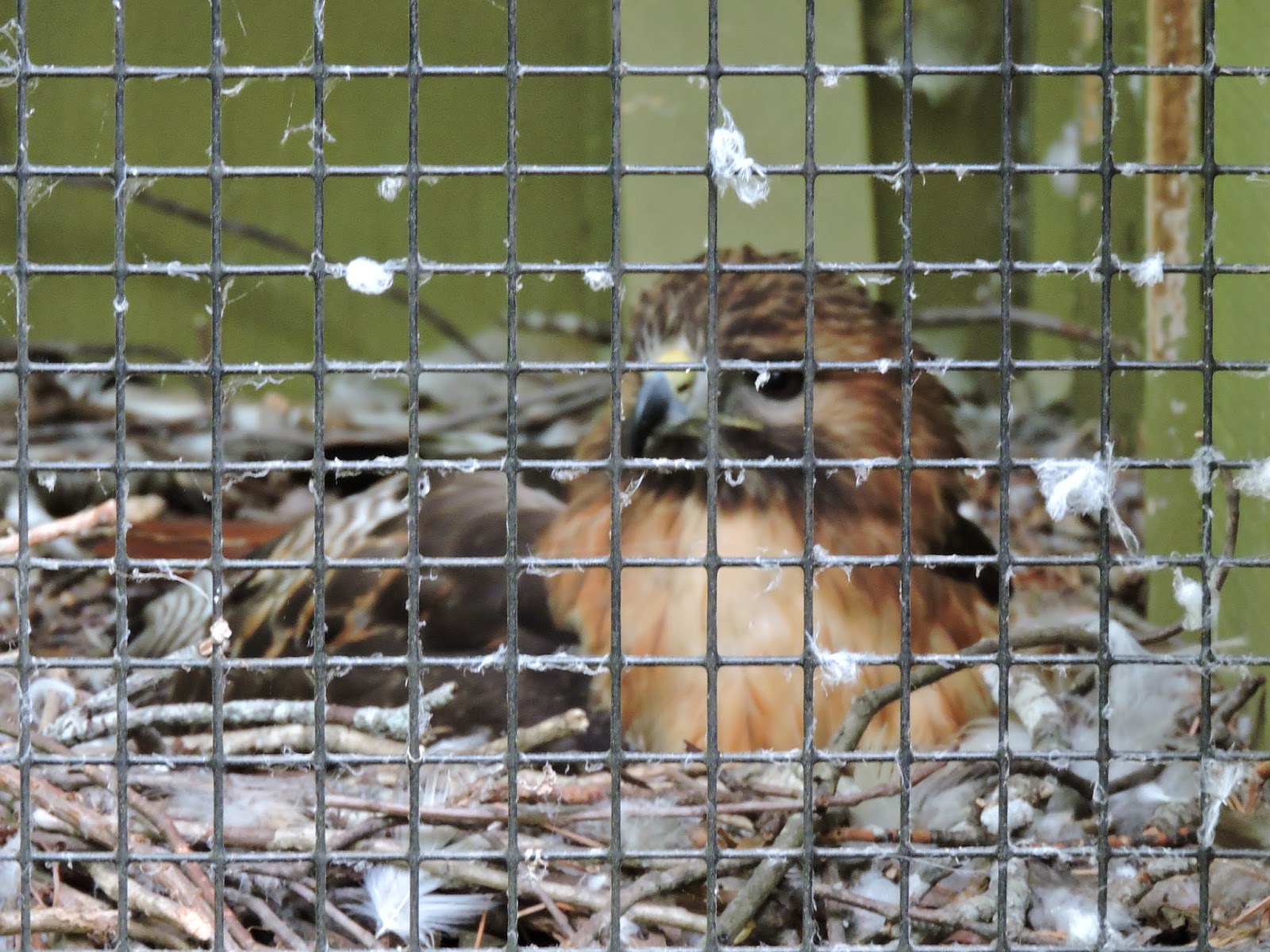
Off we went to Oak Mountain. In several cities that I know, there are large parks that are icons: Central Park in New York, Golden Gate Park in San Francisco, Griffith Park in L.A. Birmingham has Oak Mountain, and they should treasure it. Several miles long, with vast woodlands, lakes, and ranges of hills, it's a great retreat from the somewhat ordinary metropolis of Birmingham. On the way to the rehab we stopped near some rental cabins and out flew a Pileated Woodpecker. I had glimpses of this bird, a lifer for me, a few days ago, but this one offered great looks. The bird rehab facility was large and interesting. I began ID'ing new species almost from the moment I got out of the car. As we approached the entrance a staff member stepped out wearing a heavy raptor glove, on which perched a small raptor. It was a Mississippi Kite, the first I had seen in person. We talked for a while as a Gray Catbird (lifer for me) appeared in the shrub behind us. We went into the center and watched the feeders as a wave of Rose-breasted Grosbeaks mingled with Tufted Titmouse (lifer for me,) American Goldfinch, Blue Jay (a lifer for me last week,) Hairy Woodpecker, Downy Woodpecker, and other species. We stood in a darkened corridor in the treatment rooms and got dim looks at dozens of birds, orphaned or injured, in incubators and small cushioned laundry tubs. Later we checked out the large, separate raptor rehab outside. Then we went down the road to the Treetops Trail, where large cages held raptors that could never be released due to the extent of their injuries.

Nearby was "The Beach." All the soil in the area is red clay, which makes the typical lake shore unappealing. At The Beach, the state had dumped hundreds of tons of sand to make a realistic beach for swimming.


On this day, where occasional light rain showers pocked the water, the Beach was deserted. But the hot days of summer will be here soon enough and the place will be packed.
On the lawns here, we saw a few Brown Thrashers, a bird that the guidebooks claim is uncommon. We've been seeing a ton of them.

After Oak Mountain we made our way to Saw's Juke Joint to meet Kelly's mom, my ex, for dinner. Good food.
All this was yesterday. Today I was up early doing stuff for work and everyone else slept in. When we were all up and about, Kelly and I took a couple of kayaks down to the water's edge. She lives on the shore of a slough off the Coosa River. Here are some shots from sunrise.


We set off across the slough, idly targeting a Canada Goose escorting six goslings. They took to the brush-covered opposite shore to avoid us.

Kelly showed me a fascinating little bayou. The narrow inlet led to a quiet, shallow pond a couple of acres in size, completely hidden from the slough. Much of the pond was filled with plants rooted in the shallows.


We flushed a female Wood Duck with a brood of ducklings, and off they scattered into the floating weeds, which were just tall enough to hide them. We flushed a large fish, too, seeing just its back as it thrust itself out of the very shallow water into the deeper channel.
Once we were out of the little bayou we headed farther up the slough. Wild irises bloomed at a few spots along the shore.

A turtle slid off a stump that barely broke the surface of the water. Red-winged Blackbirds flew in and out of reeds. An Eastern Kingbird (lifer for me) hunted from a twig among the floating weeds.

And, as I maneuvered next to the weed beds in about a foot of water. I spotted a strange fish, motionless among the weeds. It was long and slender. I couldn't see either end of the fish but the middle of its body was patterned in darker and lighter reddish tones. I called to Kelly to come see it, and for nearly a minute it stayed motionless, within arm's reach. As Kelly approached it wiggled and slid off through the weeds.
I was really puzzled about what fish could be that color, and this evening I asked some passing fishermen about it. They had a theory that I had not considered. I checked it and found this very close match for what I had seen:
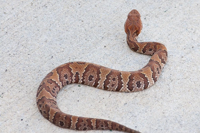
It was a water moccasin. Live and learn.Those things can remain submerged for a long time.
As we made our way back home, we passed some of the less extravagant dwellings along the slough.

I had a great time blissing out in a kayak with my lovely and talented daughter. Then the parents took the daughter to lunch in Columbiana. There's only one decent place to eat in that tiny old town, but one is enough.

After lunch, a tentative trip to a nearby state park was dismissed in favor of hanging on the deck and watching birds. \There are a lot of birds here at my ex's house. I'm just going to throw some images up here now. It was fun figuring them out. Most are not lifers for me, but they are sure uncommon for me.


And... Red-headed Woodpecker.

These photos were taken with a Nikon Coolpix P600. I like it. It is the replacement for my late, lamented, Canon SX50-HS, which was run over by a car in Texas.
Also on the reptile front, we had this visitor on the porch at the house.

It was a Green Anole (although, as you can see, they can also phase to a brown color, thus their popular name, chameleon.) It was my favorite pet as a kid.
Now I've just finished a nice home-cooked dinner. Soon I'll hit the sack and prepare for tomorrow's run to Georgia to have a motorcycle mechanic acquaintance check out the Brave Little Ninja before I make the big turn for home.
On my first full day with my daughter, Kelly, we decided to go to breakfast/lunch in Birmingham, then on to Oak Mountain State Park. As we rolled down the country roads from her house at a spirited pace, a female Northern Bobwhite Quail darted across the road. Kelly steered wide of it and was about to congratulate herself when a male darted out behind the female. The Subaru went right over him.
Kelly is pretty soft-hearted about animals. Part of our plan for the morning was to visit a bird rehab facility at Oak Mountain, and she wanted to turn around and take the quail with us. I was pretty sure that the quail was very dead, and disagreed with her at first. I gave in and we turned around and headed back to the scene of the accident. Traffic was light and no one else had passed our way in the minute or so before we got back.
The quail was exactly where we had run it over, motionless. I got out of the car, walked over to the middle of the road and... it looked intact. I approached from behind, picked it up by the sides, and it stirred a little. I got back in the car and it stirred some more. To keep it from getting spooked, I tucked its head inside my unzipped rain jacket, and we headed off toward Oak Mountain.
Well, the quail stirred again. Actually, it tried to take flight inside my jacket and ended up somewhere near my armpit. I had heard bird hunters describe bobwhites as "explosive" when they flush and that was the impression I had, too. I told Kelly to forget about the bird rehab hospital; this guy was well enough to release. We turned around again and drove back to the scene of the crime.
I thought it would be cool to get a picture of me holding a live, wild quail. I handed Kelly my cell phone and tried to extract the quail. It exploded again and flew to the floorboards on the driver's side, discovering a nook that we never knew existed, up around the roots of the gas pedal and brake pedal.
Kelly opened her door, and I opened mine. We stayed motionless. So did the quail. After a lengthy wait, I got out and began to walk over to Kelly's side to crouch down and try to extract the quail. After I had taken a couple of steps, Kelly told me that quail had bailed out. We watched as it meandered off into the tall grass and shrubs.
In other words, no picture. But a happy ending. And, up close, that quail was beautiful.
We had lunch at Big Bad Breakfast. I had a "cathead,' which is a big, homemade buttermilk biscuit with a slice of cheese and, in my case andouille sausage. Real yummy.
Off we went to Oak Mountain. In several cities that I know, there are large parks that are icons: Central Park in New York, Golden Gate Park in San Francisco, Griffith Park in L.A. Birmingham has Oak Mountain, and they should treasure it. Several miles long, with vast woodlands, lakes, and ranges of hills, it's a great retreat from the somewhat ordinary metropolis of Birmingham. On the way to the rehab we stopped near some rental cabins and out flew a Pileated Woodpecker. I had glimpses of this bird, a lifer for me, a few days ago, but this one offered great looks. The bird rehab facility was large and interesting. I began ID'ing new species almost from the moment I got out of the car. As we approached the entrance a staff member stepped out wearing a heavy raptor glove, on which perched a small raptor. It was a Mississippi Kite, the first I had seen in person. We talked for a while as a Gray Catbird (lifer for me) appeared in the shrub behind us. We went into the center and watched the feeders as a wave of Rose-breasted Grosbeaks mingled with Tufted Titmouse (lifer for me,) American Goldfinch, Blue Jay (a lifer for me last week,) Hairy Woodpecker, Downy Woodpecker, and other species. We stood in a darkened corridor in the treatment rooms and got dim looks at dozens of birds, orphaned or injured, in incubators and small cushioned laundry tubs. Later we checked out the large, separate raptor rehab outside. Then we went down the road to the Treetops Trail, where large cages held raptors that could never be released due to the extent of their injuries.
Nearby was "The Beach." All the soil in the area is red clay, which makes the typical lake shore unappealing. At The Beach, the state had dumped hundreds of tons of sand to make a realistic beach for swimming.
On this day, where occasional light rain showers pocked the water, the Beach was deserted. But the hot days of summer will be here soon enough and the place will be packed.
On the lawns here, we saw a few Brown Thrashers, a bird that the guidebooks claim is uncommon. We've been seeing a ton of them.
After Oak Mountain we made our way to Saw's Juke Joint to meet Kelly's mom, my ex, for dinner. Good food.
All this was yesterday. Today I was up early doing stuff for work and everyone else slept in. When we were all up and about, Kelly and I took a couple of kayaks down to the water's edge. She lives on the shore of a slough off the Coosa River. Here are some shots from sunrise.
We set off across the slough, idly targeting a Canada Goose escorting six goslings. They took to the brush-covered opposite shore to avoid us.
Kelly showed me a fascinating little bayou. The narrow inlet led to a quiet, shallow pond a couple of acres in size, completely hidden from the slough. Much of the pond was filled with plants rooted in the shallows.
We flushed a female Wood Duck with a brood of ducklings, and off they scattered into the floating weeds, which were just tall enough to hide them. We flushed a large fish, too, seeing just its back as it thrust itself out of the very shallow water into the deeper channel.
Once we were out of the little bayou we headed farther up the slough. Wild irises bloomed at a few spots along the shore.
A turtle slid off a stump that barely broke the surface of the water. Red-winged Blackbirds flew in and out of reeds. An Eastern Kingbird (lifer for me) hunted from a twig among the floating weeds.
And, as I maneuvered next to the weed beds in about a foot of water. I spotted a strange fish, motionless among the weeds. It was long and slender. I couldn't see either end of the fish but the middle of its body was patterned in darker and lighter reddish tones. I called to Kelly to come see it, and for nearly a minute it stayed motionless, within arm's reach. As Kelly approached it wiggled and slid off through the weeds.
I was really puzzled about what fish could be that color, and this evening I asked some passing fishermen about it. They had a theory that I had not considered. I checked it and found this very close match for what I had seen:
It was a water moccasin. Live and learn.Those things can remain submerged for a long time.
As we made our way back home, we passed some of the less extravagant dwellings along the slough.
I had a great time blissing out in a kayak with my lovely and talented daughter. Then the parents took the daughter to lunch in Columbiana. There's only one decent place to eat in that tiny old town, but one is enough.
After lunch, a tentative trip to a nearby state park was dismissed in favor of hanging on the deck and watching birds. \There are a lot of birds here at my ex's house. I'm just going to throw some images up here now. It was fun figuring them out. Most are not lifers for me, but they are sure uncommon for me.
I've seen Spotted Sandpiper (above) many times in the winter, but never in the breeding season when they actually live up to their name. And I've seen Western Bluebirds many times, but this Eastern Bluebird male and female (lifer) were exceptionally photogenic.
And... Red-headed Woodpecker.
These photos were taken with a Nikon Coolpix P600. I like it. It is the replacement for my late, lamented, Canon SX50-HS, which was run over by a car in Texas.
Also on the reptile front, we had this visitor on the porch at the house.
It was a Green Anole (although, as you can see, they can also phase to a brown color, thus their popular name, chameleon.) It was my favorite pet as a kid.
Tuesday, April 28, 2015
Past and Present
This morning's status:
I have a status meeting at work in an hour. I'll be packed up by then and ready to roll right after the phone call.
Yesterday at lunchtime I braved the brutal streets of Jackson and rode downtown, past the governor's mansion, the Capitol, and to the Supreme Court building. I parked across the street and went lunch at Two Sisters' Kitchen. It's a buffet setup in an old house. Nice surroundings and great food. Collard greens! I love those and they're hard to find in L.A. - at least, the part of L.A. that I live in.
Rain is forecast for today. It's been very light rain so far. I'm going to extend my distance a little in order to go to Selma. No, I haven't seen the movie. But I am going to go stand at that bridge and do some thinking.
After that, I'm headed to Montevallo, where my daughter attends the university. I just want to see the place. She'll be there, but she'll be in finals, so I'll ride on ahead to Wilsonville, where she lives with her mom.
And that will be the target destination. Everything after that, further explorations or the return to L.A., is open at this point. Stay tuned.
This evening's status:
I dragged myself across Mississippi on U.S. 80; bad pavement, bad drivers, and not much pretty countryside until I got far east of Jackson. I don't often photograph road signs, but this one west of Meridian got my attention.

East of Meridian I crossed the Alabama state line and suddenly the road was wonderful. Smooth pavement, higher speed limits, better scenery. Got to the Edmund Pettus Bridge in Selma and spent some time there just as the rain, which had been threatening all day, began to fall gently.


I rode north to Montevallo. Once out of town, it was a rainy but lovely ride through low wooded hills. The university was small but nicely laid out. My daughter took her car as I followed and we traveled northeast to her mom's house on a lake, a dammed portion of the Coosa River. Very nice setup.
My mileage is 29,316. I traveled 3,449 miles from L.A. to this house. I kept my vow of no freeways, but now I'm free to do as I please.
I now have a replacement camera for my smashed Canon and more photos should be forthcoming. Tomorrow? Looks like rain in the morning, so maybe an indoor activity. Like a brewery. :)
Monday, April 27, 2015
Jackson
I'm in a decent hotel room in Jackson, cranking away at work. It is centrally located near I-20, Walmart, Wendy's and Dollar Tree. No obvious flaws except for the desk chair. I already disabled one trying to adjust the height. The replacement chair sways and wobbles and projects a threatening, distrustful air. I straddle it as one would straddle a bad-tempered horse.
I patronized that Walmart in search of a better rain jacket. (The compromises that I have made on this trip out of concern for getting soaked through are kind of ridiculous.) I bought the finest rain jacket that Walmart offers, a $30 Frogg Toggs jacket that resembles an enormous gray Tyvek envelope (you know, those tear-proof envelopes that Fedex uses.) It's so big that I can just get it on over my bulky, Pillsbury Doughboy armor. The combination makes my shoulders look a hell of a lot more buff than they actually are.
Jackson has the sorriest streets I've encountered on this whole trip – certainly the sorriest streets of any state capital I've ever seen. I was already reluctant to ride after dark because of deer; here in Jackson you would be asking to get thrown from the bike just riding straight down the street at night. Even in the daytime it takes vigilance to avoid the epic potholes, one every 30 feet or so, for miles.
One odd feature of the South is that beer is significantly cheaper . Six pints of name-brand for $4.50? It's almost twice as much in California. Methinks the beer distributors in California have some kind of less-than-free market going on. And, of course, living in the South would save money on the water bill. Rain is predicted for today and intense lightning storms for tonight.
If I can get free at lunchtime, I'm gonna strap on that brand-new rain jacket and try out some supposedly very genuine Southern food, several miles away in downtown.
Sunday, April 26, 2015
Dreamtime
Today was a short-mileage day. There are two different parties east of here who I would like to meet up with, and I was within striking distance today, but neither is ready for me yet. I'm sitting in a hotel room in Jackson, Mississippi, booked for two nights, and I'm going to work a full day tomorrow. Tuesday I'll continue my travels.
As promised yesterday, I went back to downtown Natchez, extremely quiet on a Sunday morning, and took some photos. I started with the symbolic one, the little Ninja on the east side of the mighty Missippi. Vidalia, Louisiana in the background.

That shot was taken "Under the Hill," at the foot of the Natchez bluffs. Looking the other way on the road that steeply descended the bluffs, you can see the majesty of the Mississippi as it disappears into the misty upstream distance.

A lot of the downtown buildings are serving mundane purposes these days, but the architecture still catches the eye.


The very oldest building in the town is still serving its original purpose: King's Tavern.

The distance from Natchez to Jackson is only about 100 miles; maybe 120 with the extra turns I took today. But almost all the distance was covered on the Natchez Trace.


I don't know who came up with idea of constructing a 440-mile parkway along the ancient Native American trade route from Natchez to Nashville, but it was a hell of a good idea. This is a dream of a road. Although civilization is all around you, you would never know it. The National Park Service acquired a ribbon of land along the whole route, left the mature forest intact, and built a road down the middle. There are no intersections. Every road that crosses, from dirt road to interstate, is separated from the parkway by bridges. You would never have to hit the brakes if you didn't want to – but you will want to. There are numerous historical and natural exhibits along the trail. The speed limit is 50 and the parkway curves constantly as it rises and falls, with no sharp curves and no steep hills. It's almost hypnotizing in its beauty and smoothness. It's a wonderful road that gets you to thinking about the bison, the Native Americans, the Kaintucks that made this trip. If you find yourself within a day's ride of the Natchez Trace, make it a point to get there.
Sunday nights in the South, restaurants are often closed. I am going to chase down a non-chain one that is open somewhere, have a good dinner, retire early, and rise to pound out some technical publications.
As promised yesterday, I went back to downtown Natchez, extremely quiet on a Sunday morning, and took some photos. I started with the symbolic one, the little Ninja on the east side of the mighty Missippi. Vidalia, Louisiana in the background.
That shot was taken "Under the Hill," at the foot of the Natchez bluffs. Looking the other way on the road that steeply descended the bluffs, you can see the majesty of the Mississippi as it disappears into the misty upstream distance.
A lot of the downtown buildings are serving mundane purposes these days, but the architecture still catches the eye.
The very oldest building in the town is still serving its original purpose: King's Tavern.
The distance from Natchez to Jackson is only about 100 miles; maybe 120 with the extra turns I took today. But almost all the distance was covered on the Natchez Trace.
I don't know who came up with idea of constructing a 440-mile parkway along the ancient Native American trade route from Natchez to Nashville, but it was a hell of a good idea. This is a dream of a road. Although civilization is all around you, you would never know it. The National Park Service acquired a ribbon of land along the whole route, left the mature forest intact, and built a road down the middle. There are no intersections. Every road that crosses, from dirt road to interstate, is separated from the parkway by bridges. You would never have to hit the brakes if you didn't want to – but you will want to. There are numerous historical and natural exhibits along the trail. The speed limit is 50 and the parkway curves constantly as it rises and falls, with no sharp curves and no steep hills. It's almost hypnotizing in its beauty and smoothness. It's a wonderful road that gets you to thinking about the bison, the Native Americans, the Kaintucks that made this trip. If you find yourself within a day's ride of the Natchez Trace, make it a point to get there.
Sunday nights in the South, restaurants are often closed. I am going to chase down a non-chain one that is open somewhere, have a good dinner, retire early, and rise to pound out some technical publications.
Subscribe to:
Posts (Atom)