Tuesday, April 14, 2015

Work, Work, Work. Work, Work, Work.

I have paused in Marfa to catch up on an endless deluge of work. I planned to take just the one extra day but, despite having put in my 8 hours already, I don't think even overtime tonight will be enough. And at this rate the soonest I would get to Houston would be Thursday night, putting me in the office on Friday, and then two days with nothing to do? Doesn't make sense.

So I think I will stay in Marfa for three nights instead of two, getting in two full days of work. Hopefully that will relieve the pressure enough to make the rest of the trip less tense. And I'll be able to make my way to Houston with more time to explore. I'll work full-time for three or four days in Houston, then head for Alabama.

I've been computer-bound all day except for an excursion at lunchtime. I went to the Marfa Presidio County Museum, possibly the only place in town that isn't trendy, minimalist, and/or ironic. Big collection of artifacts and photos from the old days. The museum is in a house built in 1883; still looks pretty darned good today. Must have been the equivalent of a mansion back then.

One bright spot: apparently that pronghorn buck is a regular. He was back this afternoon, although still awfully distant. This time I at least got a fuzzy photo.


A peek at www.visitmarfa.com shows me that I'm taking enough advantage of all the culture here in town. I will endeavor to improve.

I have heard, through various sources, that the wildflowers along the Rio Grande are really going off right now. I look forward to that ride, day after tomorrow.

Monday, April 13, 2015

Getting my Calcium

The surface of our planet is subject to all kinds of weather. Sometimes, like today, it's the ugly kind: a gray, curdled sky, northeast wind blowing 40 MPH and gusting to 50, rain spitting sideways.

But the weather in Carlsbad Caverns, 750 feet beneath the surface, is remarkably stable all the time.

I mounted up as early as I could after the work meetings this morning and navigated the streets of Carlsbad as big pickup trucks splashed up muddy puddles. I hauled ass out to the Caverns so that I could see them and still get back to the motel by the 11:00 checkout time. The sweeping plains were beaten flat by the wind. I rode up the fun, curving road to the ridge where the Visitor Center is located, and I was the first one down in the elevator that morning. For perhaps half an hour I had the Big Room to myself. It's a convoluted cavern that covers about eight acres and rises as much as 370 feet from pit floor to ceiling, although it's mostly about 100 feet high. It's all formed of calcite, calcium carbonate. It's incredible what forms dripping water can produce. I didn't snap pictures; let me give you a link instead. The Big Room

OK, I know Carlsbad Caverns is a cliche, but it's awesome. It's exquisite, both massive and delicate. Jaw-dropping. Mind-blowing. It gives you a sense of the age and immensity of the earth. The Caverns are in the middle of nowhere between two ugly towns (El Paso and Carlsbad) but they are definitely worth going out of your way for. I jumped through some hoops for this, and I am really glad I did.

I came back up top to shrieking wind and rain. I couldn't do more than 65 MPH flat-out into the teeth of a headwind, and I got back to the motel 10 minutes before checkout. I loaded the bike and headed for Presidio, on the Rio Grande 250 miles away. Same muddy streets, same crowded highways. By far the most common vehicle was the vacuum truck, which sucks up oil from scattered rigs miles apart and transports it to centralized collection facilities.


The run from Carlsbad to Pecos, TX went through vast plains regularly punctuated by oil rigs, sometimes with flaming gas flares 10 or 20 feet long, streaming horizontally in the wind.


Surprise, Surprise, Surprise

After Pecos, the run down Highway 17 toward Balmorhea was less crowded and and a little prettier. Some irrigated fields appeared. Mountains loomed in the distance. To the west, intense rain showers poured from a bank of angry crowds. I rode faster, trying to get far enough south to dodge them. At Balmorhea I glimpsed the surprising fresh-water spring that feeds an enormous swimming pool: http://en.wikipedia.org/wiki/Balmorhea_State_Park

Then I headed through the Davis Mountains. These were lovely! What a surprise! In California they would be a national monument or some other cherished designation. I didn't take any pictures in the heights of the mountains but as the rain eased on the far side I passed these horses and decided to stop. They wondered what to make of me.


After the Davis Mountains came Fort Davis. This was a beautiful little town with a well-restored historic fort. It was kind of a boutique town, but not in an obnoxious way, and the setting was lovely. I was surprised!

I rode on another 20 miles. Along the way I spotted, of all things, a flock of 30 American White Pelicans trying hard to get north against the headwind. What were they doing here over the Chiricauan Desert? Eventually I reached Marfa.


I took this photo in honor of my sister-in-law, Martha. I'm a sucker for dumb humor. Hi, Marfa!

My original plan had been to continue on to Presidio but... there was something different about this town. Heck, there were a lot of things different. Art galleries were everywhere. Genuine hipster vehicles roamed the streets. An encampment in the south side of town was like a permanent, small-scale Burning Man. Here, see what I mean. What a surprise! to find something like this in such a backwater part of the state.

I found a room at the Riata Inn, on the very eastward fringe of town. After I unpacked I wandered off into the nearby field, toting binoculars to look for birds, and suddenly realized there was a pronghorn antelope buck several hundred yards out. I went back for the camera but it was too far out for a good photo. In the photo below, the view from my room, it was in the exact center of the photo. I love pronghorns. Score.


As I write this, there's a sliver of rainbow on the horizon, right above the spot that the pronghorn appeared. I'm off to get some grub and check out the hipsters.

It's Like I Never Left L.A.

In Marfa all but two of the restaurants close on Monday night. I ended up at Jett's Grill at the Paisano Hotel. It was completely full. I swear, I could have been in Santa Monica. All correct hairdos (the men, too), industry talk, and killer shoes. Not even a trace of a cowboy hat in this West Texas restaurant. The Paisano is a gorgeous hotel – it would be in the top rank of boutique hotels in, say, Palm Springs. It got me to wondering; am I just the last to know about Marfa? Before dinner I had a beer at the working-class Lost Horse Saloon just down the road from my motel. I fell in with some genuine locals who knew this town before it got artsy. They told me that stars like Johnny Depp come here because no one knows who they are, and the stars really like that. Hugh Hefner was here with a Playmate of the year, to visit a Playboy-themed piece of installation art that was eventually taken down for lack of a building permit. Oh, brother. Maybe I'll get back to Just Plain Folks on Wednesday.

Sunday, April 12, 2015

Weather You LIke It or Not

I've been in this ragged little motel in Carlsbad for a few hours now. I'm only now getting around to blogging.

Motels are expensive here. This one was $78, tax included, and it was the lowest price in town. Quite a third-rate motel, too. I don't know why motels command such prices here, but I think it's related to all the oil and gas activity in the Permian Basin, the edge of which extends into New Mexico.

OK, weather. There aren't any photos from today, because I was afraid to get the camera wet. I covered about 250 miles, about 90% of that in the rain. I learned that my rain gear works well for an hour or so but, in a stretch of many hours, I get wetted through. At 70 MPH with temps in the 60s, that means I get pretty cold.

I left Columbus in the rain and flew through more endless plains with scattered, abrupt, miniature mountain ranges. In the worst part of the day, I navigated highways 85 and 62 through the heart of urban El Paso before 62 headed out into the Big Wide Open. In a couple of rain-soaked urban turns today I felt the front end slide out ever so slightly, a sensation guaranteed to get one's attention.

Anyway, once 62 got out into the countryside, the views were epic. West Texas is big, just like eastern Arizona and most of New Mexico. Along the way to Guadalupe Mountains National Park (90 miles) there was the infrequent failed cafe, motel, or RV park. But mostly it was uninterrupted rangeland as far as the eye could see. The soul sort of streches out in views like those.

Finally the highway approached the Guadalupe Mountains and began climbing. The storm that accompanied me all day spilled around the peaks; only the lower flanks were visible. But those were pretty awesome. I stopped at the Visitor Center anyway, and admired the 5700-foot biome, yet the summits remained cloaked by wind-whipped clouds and the rain still fell.

Away I went toward Carlsbad. It was too late in the day to stop at the Caverns, and I didn't want to park the bike with all the luggage on it anyway. I went on to the town of Carlsbad, where I learned about the motel economy.

Tomorrow my plan is to be at Carlsbad Caverns when they open at 8:30, leaving the luggage here at the motel, then zip back, pick up the luggage, and make an epic ride southward through Texas to get closer to Big Bend National Park. The forecast is for heavy rain tonight and 70% chance of thunderstorms tomorrow. Should be interesting.

Saturday, April 11, 2015

Saturday NIght in Old Mexico


The title is a little too grandiose. I'm in Columbus, New Mexico, mostly famous for being the victim of a raid by Pancho Villa in 1916, and the retaliatory "Punitive Mexican Expedition" by General John Pershing, as in the Pershing Tank, Pershing Square in L.A., etcetera. Columbus is 3 miles north of Palomas, Chihuahua, Mexico. So I rode to the border, parked the bike, and walked across for dinner.

This day started early. I left most of my stuff at the motel in Sierra Vista, threw birding stuff into a backpack, and drove to the main gate of Fort Huachuca. I drove through the base to Huachuca Canyon, where the road transitioned from pavement to rocky dirt. I had a tense ride a couple of miles up the canyon and parked the bike where I saw a couple of other vehicles. I associated loosely with some other birders for the next two hours.

The red vehicle in the background is the preferred vehicle for Huachuca Canyon Road. The yellow vehicle in the foreground is not recommended. The Jeep driver asked me if I was crazy.


Almost all of my birding has been done in California, so it was inevitable that I would pick up several new birds on this outing. The canyon is beautiful, too.


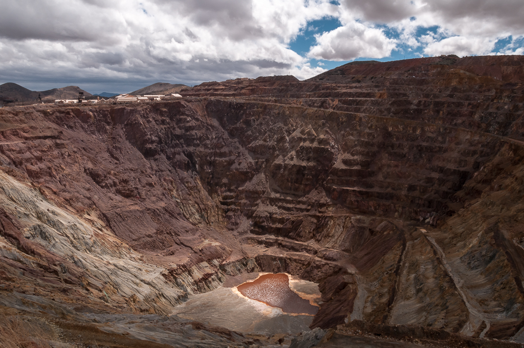
After my successful outing I headed back down the canyon road (wincing every time rocks bashed my wheels), through the base, and back to the motel. By the time I hit the road it was nearly noon. I headed for Bisbee, where a lot of weekend tourists also seemed to be going. The enormous open-pit copper mine there could swallow the Golden Gate Bridge without having the towers stick out.


Bisbee is at 5300 feet and the road there crests some higher elevations before getting there, so clearly my first-day elevation of 4400 is nothing special.

After Bisbee I headed for Douglas, AZ on the Mexican border. The road descended Whitewater wash to a huge plain covered in thorn trees and other scrub. Douglas is an old town with buildings up to five stories high downtown; pretty good for old Arizona. After lunch and fuel I took off for Columbus.

The first several miles were not very attractive, but then the views got enormous and pretty. It really puts you in an extraordinary mindset. This was a lightly traveled road. In contrast with the dozens of motorcycles I saw on my way to Bisbee, I saw not a one in the 144 miles from Douglas to Columbus. 

When I took that shot of the Ninja, shown at the top of this post, I was about a mile north of a historical marker, the place where Geronimo surrendered to U.S. troops. It makes you think, to be there in that largely unchanged land. History becomes more real.

I've seen lots of wildflowers on this trip but haven't taken many pictures. Here is my attempt to make up for that. Most of these were taken on Arizona 80 near the New Mexico line.


And there was a small but important milestone today! 


Those clouds that you saw in the earlier photos increased and thickened tonight while the constant west wind continued. And now it's really blowing. A Great Horned Owl hooting outside the motel room was serenading me but this weather might put a stop to that. There might be thunderstorms tomorrow. This will be my first chance to try the rain protection gear that I brought for me and for my luggage. Crossed fingers. 


Lifers at Fort Huachuca

No, not the grizzled sergeants who are going to stay in the Army until they're kicked out. For my non-birding friends, "lifers" are "life birds" – birds that you have never seen before. I got four lifers this morning in Huachuca Canyon on the Army base: Elegant Trogon (looks like a Disney character), Bridled Titmouse, Mexican Jay, and Red-faced Warbler. And saw a couple of others for only the second or third time: Painted Redstart and Hepatic Tanager. More details later. I'm packing up and heading for New Mexico.

Friday, April 10, 2015

Border Patrol

Although I can't hug the border most of the time on this trip, the Border Patrol has generously extended its coverage to the routes I'm on. I passed through three checkpoints today, although because of the direction I'm going, I only had to stop for one of them.


10 miles from Ajo is a little wide spot in the road named Why. When I saw that I knew that a photo was mandatory.


Ajo is close to an Air Force bombing range. (The Barry Goldwater Air Force Range. You gotta love it.) Ten minutes after this photo, I was overflown by a couple of A-10s about 200 feet above the ground, weaving between hills. The A-10 is my favorite military plane, so that gave me a little thrill.

I spent over an hour going through the seemingly endless Sonoran Desert on the Tonoho O'odham reservation. Lots of beautiful scenery, great roads, modern facilities. I'm guessing this tribe has good income streams from the military and from the Kitt Peak astronomical facilities.

Speaking of Kitt Peak, here it is, as a backdrop to a nice stand of blooming ocotillo and palo verde. You can just make out one of the observatories on the summit.


Kitt Peak is one of the "sky islands" that rise thousands of feet above the Sonoran Desert. The plants and animals up there, completely different than their desert counterparts, are evolving apart from those on the other summits, because the desert acts as a barrier to mingling.

After the Kitt Peak junction the highway eased down into a vast plain and things got increasingly urbanized as I skirted the south edge of Tucson. Things got very urbanized, in fact, with rampant road construction that went on for miles and the unique qualities of Arizona drivers, who are so sociable that they like to drive abreast in every traffic lane. Preferably 10 MPH under the speed limit.

I left Greater Tucson and headed south to Sahuarita, then east to Highway 83. Prickly pear cactus, which I hadn't seen since the first day, returned in force. I turned south on 83 and climbed and climbed the hills. This was a landscape which, while vast, was kind of ugly. The only greenery came from thorn trees in the bottoms of gullies. The ocotillo and other shrubs on the hillsides looked brown and dead. As I finally crested the summit, the landscape changed in the blink of an eye and I was in oak savannas covering the hills. Around Sonoita, the oaks disappeared and all was rolling grass steppes to the distant mountains. Remember my claim of highest elevation for the whole trip on the first day? I may have been wrong. The steppes descended eventually to Huachuca City, at 4275 feet, so I suspect I was higher than the first day's 4400 feet at some point.

Now Let's Laugh at Mark

Hey, you won't be the only one. I've been laughing at me, too. Remember, on the first day, when I changed helmets after the photo was taken because I couldn't bear the slight scratches on the face shield of the original helmet? Well, here's a photo of my current helmet after a day's ride.


And this is just the Arizona desert! I can't wait until I get to some fertile farmland. I'll probably have bugs a quarter of an inch thick on the shield.

Jupiter Pops

The Kitt Peak observatories in southern Arizona are the premier astronomical site in the U.S. because of their location, far from the light pollution of any urban center. Kitt Peak isn't close to any town but, it's probably closest to Tucson. Next closest would be Ajo, my current location.

Ajo was a happening place when the enormous open-pit copper mine was running. The miles-wide pile of tailings outside of town testifies to the sheer economic power that suddenly ended in 1983, when the company decided that the mine wasn't profitable. 80% of the residents moved away. The remainder seem quiet, cowed, almost haunted. Remnants of Ajo's former prowess remain. It has a beautiful central plaza that would be the envy of any town in the U.S., but the shops beneath the arcade are thinly stocked, closed before five, weak and tentative. Yard sales are everywhere, and you can tell that the stuff has been sitting out in those yards for a long time. The main business in town seems to be Mexican auto insurance agencies catering to motorists headed for Rocky Point on the Gulf of California, 100 miles south.

Even so. It's beautiful here. The desert hills reveal their volcanic origins and crazy shapes. The ocotillo and the palo verde are in bloom. Birds are everywhere. Last night, walking from the local roadhouse back to the motel along the nearly deserted highway, I gaped at the constellations, the original light show. Jupiter looked like a searchlight and even the more restrained Saturn was showing off. The stars pop in Ajo.

Botanicals

My winding way southeast covered many habitats, although there were no transitions that were obvious to the untrained eye. The omnipresent, flowering palo verde trees yielded to a few scattered saguaro cactus. As I left the hamlet of Hope (Sign says: Your [sic] Now Beyond Hope) I rode through an intense little pocket of flowering ocotillo against dark rocky cliffs. If I had known that this location would be the most photogenic of the day, I would have stopped. :)

Later the saguaro habitat added barrel cactus and, later, cholla cactus. Sage gave way to creosote. But the palo verde trees continued their intense yellow bloom during the entire 200 miles.


Paved... or Not

This goal of never getting on a freeway makes for some diligent route planning. The map indicated a highway running from Salome southeast to Buckeye, crossing Interstate 10 along the way. Indeed, from Salome to 10 it was a nice road and a beautiful ride. But as soon as it crossed 10...

Now what? It was a long way back to anywhere that would provide an alternate route, but it was only a quarter-mile back to the freeway. Yeah, I could get on 10 and be in Buckeye in 15 minutes. But I hated to give up on the no-freeway goal. Eventually I climbed on and took the heavily loaded Ninja down that dirt road. Even if it was 18 miles of dirt, I would just go slow and pray.
In places the gravel got deep and the front tire developed a mind of its own, pretty terrifying for a guy like me who didn't learn to ride dirt bikes. I saw no sign of humanity except for an electrical substation that clearly was fully automated and wouldn't even be checked on for, I dunno, the next month or two. Then I started thinking about flat tires.

After five long, nail-biting miles, pavement resumed. I thought about kissing it, but declined.

Birds

At the same point that the pavement stopped, while I was pondering my fate, I noticed raptors circling above an irrigated field. I snapped a few blurry shots of the moving birds. Image stabilization didn't help much.

See what I mean? It's even hard to tell whether the bird is moving left, or right. (For the record, it's right.) I had no idea what these were. I had never seen a hawk with white at the front of the wing and dark at the back - usually it's the other way around. The wings were pointed enough to resemble falcons, but a whole team of falcons working a single field? My bird ID aid is an application on a Kindle, and the Kindle doesn't do well in bright sun. Later, at a lunch stop in Gila Bend, I pored through descriptions of all the hawks and found nothing that matched until I got to Swainson's Hawk, the light-colored form. My previous looks at Swainson's, in California, were distant views. These birds are gorgeous closer up.

As I write this, dawn has come in the desert. The light seeps in slowly and thinly, building long before sunrise. I began hearing bird calls and then strange noises outside my door, scratches and bumps. I got dressed and stepped out. When I saw what was going on, I went back inside for the camera.


And it wasn't just one Cactus Wren – it was a herd of Cactus Wrens, carrying food to begging fledglings, checking every crevice, chattering and squawking. The place is rife with other bird species, too. Nature permeates this little town. 

Today I take a long ride through the Tohon O'odham reservation, past the Kitt Peak turnoff (which I will resist) and around the southern edge of Tucson, headed for Sierra Vista. I hope to get some birding done in that target-rich environment this weekend.